【01】mapbox js api加载arcgis切片服务
发布时间:2024年01月18日
需求:
第三方的mapbox js api加载arcgis切片服务,同时叠加在天地图上,天地图坐标系web墨卡托。
效果图:
形如这种地址去加载http://zjq2022.gis.com:8080/demo/loadmapboxtdt.html

思路:
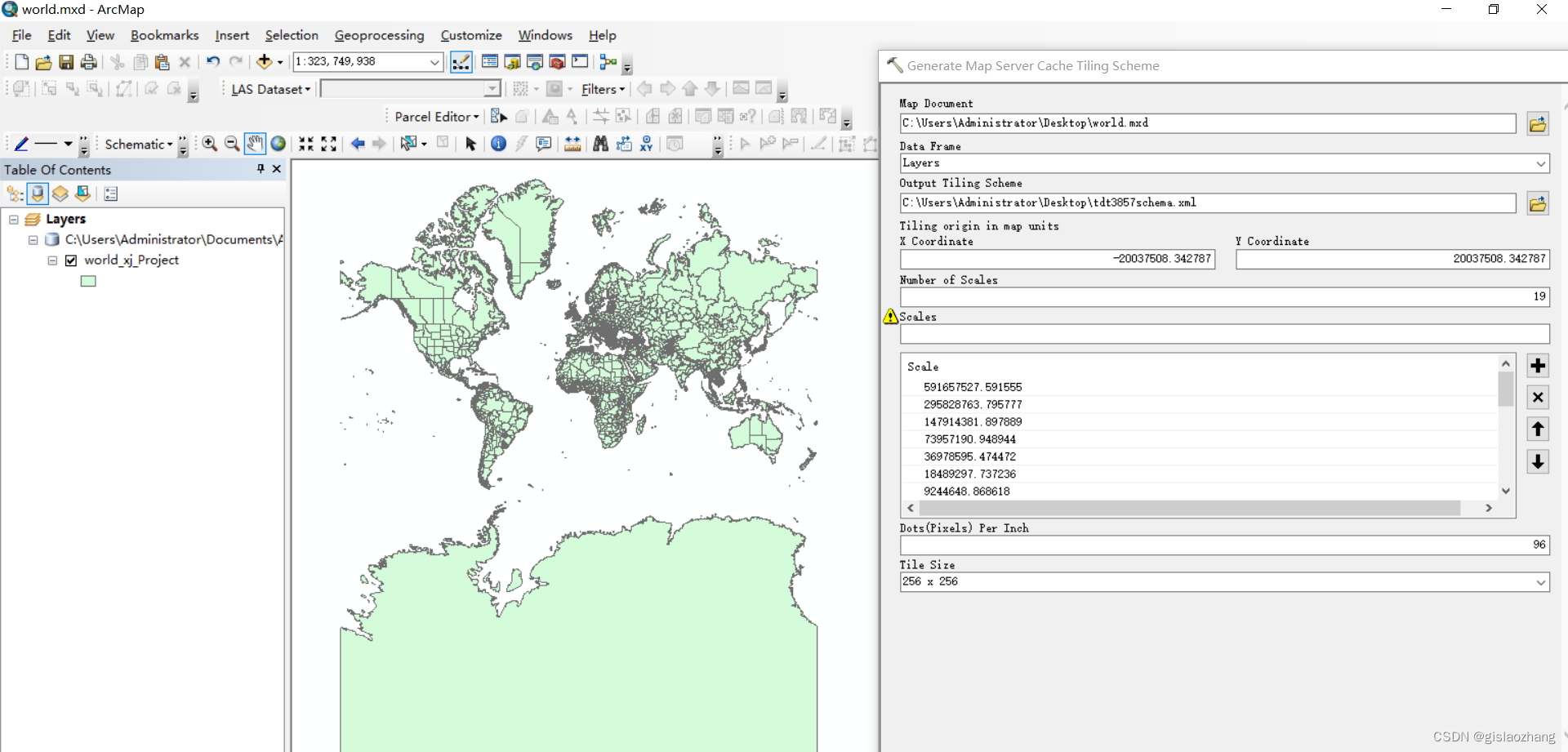
需要制作一个和天地图比例尺级别以及切片大小等一样的切片方案,可以通过arcmap或者arcgispro制作。如图:
具体的切片信息参数参考链接:
arcgis javascript api4.x加载天地图web墨卡托(wkid:3857)坐标系_acrgis 加载墨卡托地图-CSDN博客

制作出的切片方案见链接:
链接:https://pan.baidu.com/s/1fezUPJnp-G0g6cpcbsOuEw?
提取码:gfwm?
使用该切片方案去切片。
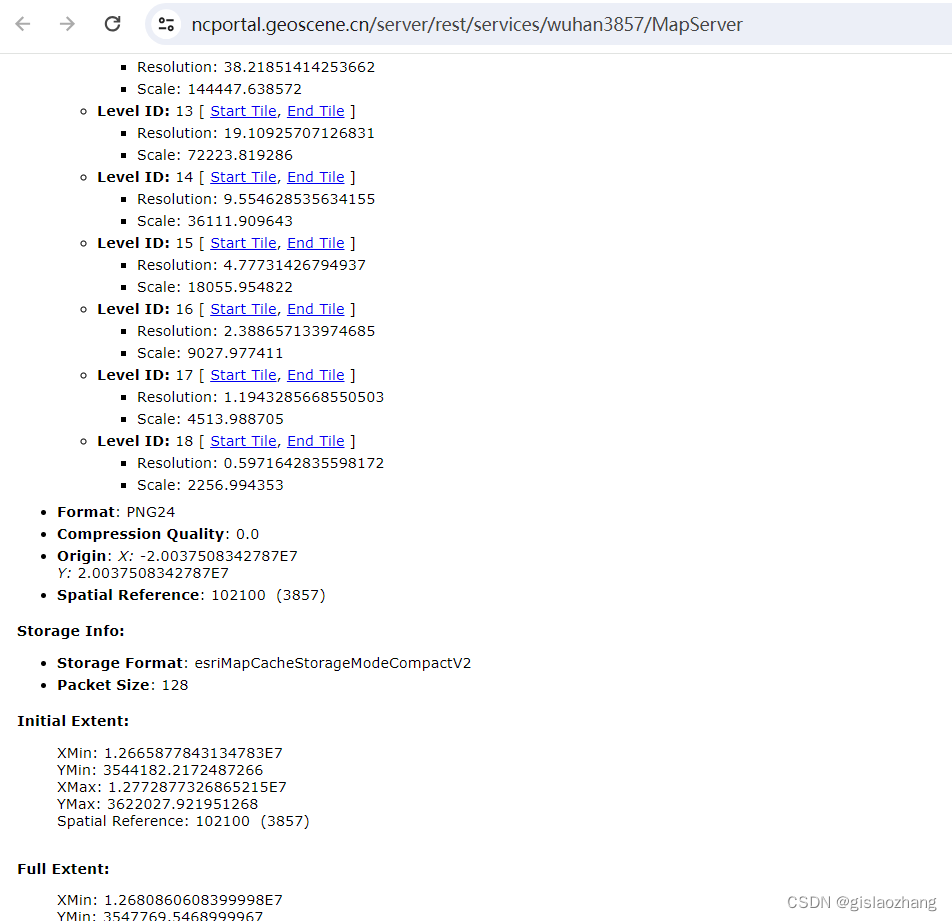
切片之后的效果:

mapbox加载arcgis切片服务示例代码:
<!DOCTYPE html>
<html>
  <head>
    <meta charset="utf-8" />
    <title>mapbox 添加arcgis rest切片地图服务</title>
    <meta
      name="viewport"
      content="initial-scale=1,maximum-scale=1,user-scalable=no"
    />
    <script src="https://api.mapbox.com/mapbox-gl-js/v2.15.0/mapbox-gl.js"></script>
    <link
      href="https://api.mapbox.com/mapbox-gl-js/v2.15.0/mapbox-gl.css"
      rel="stylesheet"
    />
    <script src="https://cdn.bootcdn.net/ajax/libs/axios/0.19.2/axios.js"></script>
    <style>
      body {
        margin: 0;
        padding: 0;
      }
      #map {
        position: absolute;
        top: 0;
        bottom: 0;
        width: 100%;
      }
    </style>
  </head>
  <body>
    <div id="map"></div>
    <script>
      const vecUrl =
        "http://t0.tianditu.com/vec_w/wmts?tk=317e52a409b6b382957e09003ee7e235";
      const cvaUrl =
        "http://t0.tianditu.com/cva_w/wmts?tk=317e52a409b6b382957e09003ee7e235";
      var tdtVec = {
        type: "raster",
        tiles: [
          vecUrl +
            "&SERVICE=WMTS&REQUEST=GetTile&VERSION=1.0.0&LAYER=vec&STYLE=default&TILEMATRIXSET=w&TILEMATRIX={z}&TILEROW={y}&TILECOL={x}&FORMAT=tiles",
        ],
        tileSize: 256,
      };
      var tdtCva = {
        type: "raster",
        tiles: [
          cvaUrl +
            "&SERVICE=WMTS&REQUEST=GetTile&VERSION=1.0.0&LAYER=cva&STYLE=default&TILEMATRIXSET=w&TILEMATRIX={z}&TILEROW={y}&TILECOL={x}&FORMAT=tiles",
        ],
        tileSize: 256,
      };
      mapboxgl.accessToken =
        "pk.eyJ1IjoibHh0aWFudGlhbiIsImEiOiJjaXd2ZjlkYnQwMTZvMnRtYWZnM2lpbHFvIn0.ef3rFZTr9psmLWahrqap2A";
      var map = new mapboxgl.Map({
        container: "map", // container id
        center: [114.32021, 30.578322], // starting position
        style: {
          version: 8,
          glyphs: "mapbox://fonts/mapbox/{fontstack}/{range}.pbf",
          sources: {
            tdtVec: tdtVec,
            tdtCva: tdtCva,
          },
          layers: [
            {
              id: "tdtVec",
              type: "raster",
              source: "tdtVec",
            },
            {
              id: "tdtCva",
              type: "raster",
              source: "tdtCva",
            },
          ],
        },
        zoom: 12, // starting zoom
        minZoom: 1,
        maxZoom: 18,
      });

      map.on("load", function () {
        map.addSource("arcgissource", {
          type: "raster",
          tiles: [
            "https://ncportal.geoscene.cn/server/rest/services/wuhan3857/MapServer/tile/{z}/{y}/{x}",
          ],
          tileSize: 256,
        });
        map.addLayer({
          id: "tdt-img-tiles",
          type: "raster",
          minzoom: 0,
          maxzoom: 19,
          source: "arcgissource",
        });
      });

      // // 添加argis rest 动态地图服务
      // map.on("load", function () {
      //   map.addSource("city-source", {
      //     type: "raster",
      //     tiles: [
      //       "https://whgeoscene.hygt.com/server/rest/services/全国道路/MapServer/export?dpi=96&transparent=true&format=png8&layers=&bbox={bbox-epsg-3857}&f=image&bboxSR=102100&imageSR=102100",
      //     ],
      //     // 'tiles':['http://localhost:6080/arcgis/rest/services/MyMapService/MapServer/export?dpi=96&transparent=true&format=png8&layers=&bbox={bbox-epsg-3857}&f=image&bboxSR=3857&imageSR=3857'],
      //     // "tiles": ['http://221.239.0.144:6080/arcgis/rest/services/oceanname_vector/MapServer/export?bbox={bbox-epsg-3857}&f=image&transparent=true&format=png8&bboxSR=102100&imageSR=102100'],
      //     tileSize: 256,
      //   });
      //   map.addLayer({
      //     id: "sity-layer",
      //     type: "raster",
      //     source: "city-source",
      //   });

      // });
    </script>
  </body>
</html>
参考资料:
文章来源:https://blog.csdn.net/gislaozhang/article/details/135679270
本文来自互联网用户投稿,该文观点仅代表作者本人,不代表本站立场。本站仅提供信息存储空间服务,不拥有所有权,不承担相关法律责任。 如若内容造成侵权/违法违规/事实不符,请联系我的编程经验分享网邮箱:chenni525@qq.com进行投诉反馈,一经查实,立即删除!
本文来自互联网用户投稿,该文观点仅代表作者本人,不代表本站立场。本站仅提供信息存储空间服务,不拥有所有权,不承担相关法律责任。 如若内容造成侵权/违法违规/事实不符,请联系我的编程经验分享网邮箱:chenni525@qq.com进行投诉反馈,一经查实,立即删除!
最新文章
- Python教程
- 深入理解 MySQL 中的 HAVING 关键字和聚合函数
- Qt之QChar编码(1)
- MyBatis入门基础篇
- 用Python脚本实现FFmpeg批量转换
- Spring Cloud Alibaba整合RocketMQ架构原理分析
- Python基础知识:整理8 函数进阶
- 轮排索引相关知识
- MySQL,分组order by
- LDR伪指令和ADR指令的区别
- 基于springboot+uniapp的图书馆座位预约小程序(Java毕业设计)
- Linux 中常用的 systemd 命令讲解
- 数仓建设学习路线(四)-指标体系建设
- centos7系统部署SqlServer2019
- Python 爬虫开发完整环境部署,爬虫核心框架安装